The Bondi to Manly Walk

When I say I’m walking from Bondi to Manly I get two responses. “How long will that take, a day?” or “Blimey, how many days will that take?”. It speaks volumes about Sydney’s geography, or people’s geographical perceptions.
As the seagull flies, it’s 11km from Bondi Beach in the south to Manly Beach in the north; or 23km if you’re driving. But following the foreshore via Sydney Harbour and Spit Bridges, it’s a whopping 80km on foot. The route meanders between beaches and bushland, city and suburban streets, taking in Indigenous, colonial and military sites. Given Sydney’s terrain, there are also numerous hills and stairs to climb.
Many of the Eora nation’s harbourside pathways were consumed in the colonial lust for waterfront property, leaving isolated pockets of public foreshore. It wasn’t until 2019, following unprecedented cooperation between government agencies, councils and volunteers, that existing paths were connected creating one epic city hike. The Bondi to Manly Walk website is run by volunteers and offers a route booklet and app.
But I recommend Tara Wells’ definitive guidebook, The Bondi to Manly Walk, available at bookstores. She spent her honeymoon on the walk before it was formalised and reveals fascinating facts in easy-to-read prose, while providing directions, transport and accommodation details.
I tackle the walk over five days, staying two nights at both Circular Quay and Manly, but I recommend a more leisurely pace.
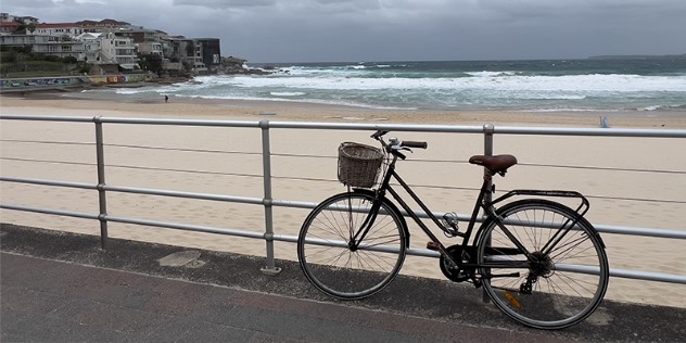
Bondi Beach on a blustery morning.
Bondi to Rose Bay
Commencing at Bondi Beach Surf Life Saving Tower, I head north and dodge joggers, dog walkers and mothers with strollers. Autumn waves curdle and crash on the beach, closing it for swimming, and wind knocks over the last of my coffee.
I’m mesmerised by sea-green spume surging into North Bondi Pool and miss the first route marker, a yellow-on-black Aboriginal design of mundoes (ancestral footprints) over a whale silhouette. Signage is inconsistent, but with Tara’s book or the app you can’t go (too far) wrong, the trickiest being detours around private homes in prime waterfront positions.
Surprises come thick and fast. At the cliff-hugging Bondi Golf Course, sandstone peeks through clipped lawns to reveal Aboriginal engravings of fish, sharks, whales and a possible ancestral figure. It’s a magnificent location with Pacific Ocean views, now incongruously close to a lighthouse-like tower that’s a heritage-listed sewer vent.
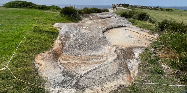
Aboriginal engravings within Bondi Golf Course.
The rock-front stairs of Federation Cliff Walk are under repair, necessitating detours to reach its grassy clifftops popular with professional dog walkers wrangling designer breeds. Radar operated here during WWII, and post-war the CSIRO established an internationally acclaimed radio astronomy site, making discoveries that revolutionised space exploration.
Dazzling Macquarie Lightstation, built in 1883, sits on the site of Australia’s first lighthouse completed in 1818. At Gap Bluff the sandstone escarpment plunges 80m to the sea where waves pummel in a relentless roar. Infamous as a suicide spot, the cliffs are now fenced off and helpline numbers are prominently displayed. It’s heartwarming to read Tara’s account of local Don Ritchie who saved many lives with his friendly smile and offers of help.
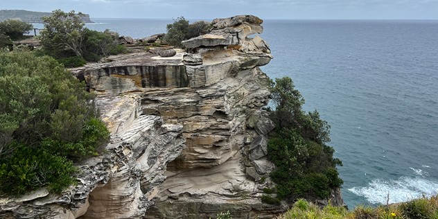
Sandstone cliffs at The Gap.
I drop down to Camp Cove, cornered in the lee of South Head, where Captain Arthur Phillip first set foot on Port Jackson. After lunch at the colourful beach kiosk, I follow South Head Heritage Trail. Jaunty red-and-white striped Hornby Lighthouse is swathed in scaffolding mesh while undergoing restoration. It was built in 1858 following the wreck of the Dunbar that claimed 121 lives. In a fitting twist to the story, the sole survivor and his brother became lighthouse keepers there.
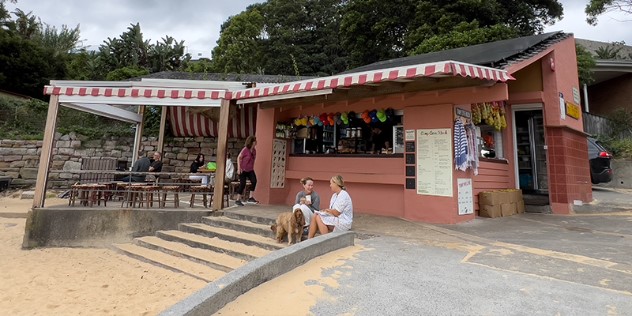
Camp Cove Kiosk, Watsons Bay
The harbour is awash with watercraft – kayaks, cruisers, racing yachts, ferries and even a colossal cruise ship – as I head to Green Point. In 1942, an anti-submarine boom net was installed between Green Point and Georges Head, snaring one of three Japanese midget submarines, which self-detonated to avoid capture.
After bustling Watsons Bay, petite Parsley Bay gleams like a pearl in a green-lipped shell, complete with a necklace-like white suspension footbridge. Once part of William Wentworth’s 208-hectare Vaucluse Estate, it was protected for public use, along with other sections of waterfront, thanks to sailor William Notting whose campaigning in the late 1890s resulted in the Foreshores Resumption Scheme. Vaucluse House is now a museum.
The Hermitage Foreshore Track feels like a wilderness nature trail, with city vignettes glimpsed through she-oaks and wattles. It passes miniscule Milk Beach beneath the grounds of Strickland House, perfect for a picnic. Rose Bay, where I catch the ferry to Circular Quay, was Sydney’s first international airport, home to Catalina flying boats.
Milk Beach below Strickland House, Vaucluse.
The 21km journey makes me grateful the Four Seasons Hotel is so close to the Quay and overjoyed my room has a bath. After a soak, I relax on the banquet window seat and then head to Executive Lounge 32 for a complimentary prosecco with harbour vista. I’d planned to dine at in-house Mode Kitchen & Bar, but graze on the lounge’s hors d’oeuvres instead.
Rose Bay to Neutral Bay
The morning ferry to Rose Bay takes 13 minutes. It will take me five-and-a-half hours to walk back. From busy New South Head Road it’s into Point Piper, Sydney’s most expensive suburb. An army of maintenance workers tend properties that boast names as well as numbers. Views are glimpsed through gates, but Tara recommends Duff Reserve, “At the bargain cost of 97 stairs.” I’d argue its 100, but worth the workout for the pocket handkerchief-sized waterside park.
I’d never heard of Seven Shillings Beach and sense the leathery local in speedos setting up his deckchair wants to keep it that way, ignoring my salutation. Not so at netted Murray Rose Pool, where everyone’s as cheery as the murals next to Redleaf Cafe.
I follow Double Bay Tree Trail through Blackburn Gardens, watch skiff sailors rigging up beneath Moreton Bay figs in Steyne Park and ogle superyachts at Rushcutters Bay. Another of Tara’s gems is McElhone Reserve in Elizabeth Bay, an emerald oasis with koi pond and frangipani-framed vistas.
Suddenly I’m in the city negotiating school excursions and cruise ship passengers around Mrs Macquarie’s Chair, the Botanic Gardens, Opera House and The Rocks. Crossing the Harbour Bridge I climb the 200-plus steps to the Pylon Lookout & Museum, worth it for the views alone. Jutting into the harbour at Milsons Point is the bow of the original HMAS Sydney. Later I’ll see it’s mast at Bradleys Head, erected to commemorate Australian ships and crew lost in combat.
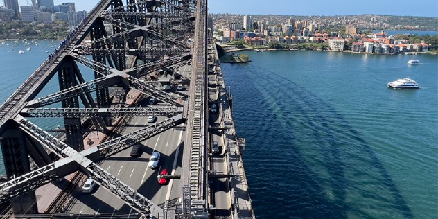
Sydney Harbour Bridge from Pylon Lookout & Museum.
“Sure, go for it,” says the policewoman when I ask if I can photograph Admiralty House gates. Equally surprising is slender Lady Gowrie Lookout next to Kirribilli House, terraced down to the water. Sub Base Platypus, once a torpedo factory and submarine base, is now a contemporary work and recreation hub. Nearby Neutral Bay’s Anderson Park was famously used by aviator Charles Kingsford Smith as a makeshift runway for his Lockheed Altair Lady Southern Cross in 1934. After walking 22km, I could do with a flight home but settle for the Neutral Bay ferry.
At Four Seasons’ Grain Bar, manager Marco explains their eucalyptus-infused bespoke gin was developed with Bondi Liquor Co, so I order their gin-based ‘In Like Flynn’ cocktail. I add a charcuterie and cheese board and call it dinner.
Neutral Bay to Balmoral Beach
I breakfast on the balcony of the quirky Thelma & Louise café at Neutral Bay Wharf. Other nuggets nearby include May Gibbs’ Nutcote museum and a rose-covered nature strip at Kurraba Point by award-winning grower Mark McGuire. Cremorne Reserve edges the peninsula with pockets of bush full of birdsong, sculptural fig tree roots, and the Lex and Ruby Graham ‘guerrilla garden’ they coaxed from weed-infested public foreshore. At Robertson Point Lighthouse I meet the wryly named ‘Walkers Without Walkers’ on their weekly 10km morning amble.
I grab lunch for later from Mosman Wharf and continue to Sirius Cove, where artists Tom Roberts and Arthur Streeton, among others, lived under canvas while painting en plein air in the 1890s. Skirting Taronga Zoo there’s plenty of wildlife on the path beneath statuesque Sydney red gums – eastern water dragons, bush turkeys, even a green tree snake. Military history abounds here. Bradleys, Georges and Middle Heads are a maze of fortifications and Taylors Bay is where two navy-requisitioned Halvorsen cruisers depth-charged the second Japanese midget submarine.
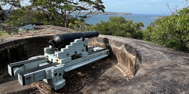
Georges Head Battery, Mosman.
After 20km it’s late when I descend the staircase to Balmoral Beach. I’d planned to reach Spit Bridge and bus to Manly, but I Uber from Balmoral instead. At Manly Pacific MGallery it’s straight to the rooftop pool to cool off, then a street-side table at bar 55 North for dukka spiced burrata washed down with a Paloma Spritz. My balcony room overlooks the beach and I watch the evening passeggiata before bed, sleep listening to the surf, and wake to sunrise through the Norfolk pines.
Balmoral Beach to Manly
Breakfast is at Bistro Manly before catching another Uber back to Balmoral. People chit-chat under the fig trees, bathing-capped bodies bob through the water and a couple of bronzed gents on the sand hold plank positions so long I worry rigor mortis has set in. The charming esplanade is ornamented with a wedding cake-style columned rotunda and dinky arched footbridge to Rocky Point Island.
On the far side of Spit Bridge, the route follows the Spit to Manly Walk, past sandstone overhangs dripping with ferns. In the 1860s spacious Clontarf Reserve housed a dance hall and pleasure gardens, but it’s infamous for the 1868 assassination attempt on Prince Alfred, Duke of Edinburgh while he was the guest of honour at a sailor’s picnic. Today, people are painting en plein air, swimming their dogs and learning to sail.
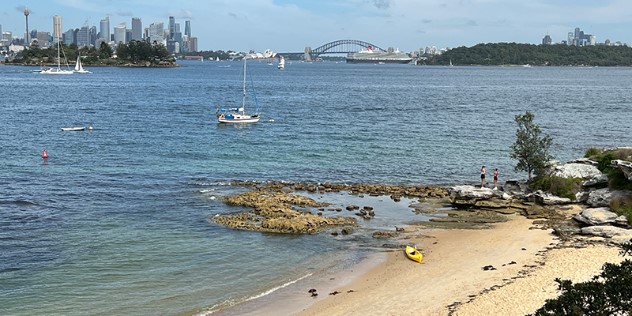
The whole headland beneath Balgowlah Heights is part of Sydney Harbour National Park and Aboriginal engravings reflect the importance of this area to the Gamaragal people. Kookaburras cackle from the trees, native flowers flourish along the track to Grotto Point Lighthouse, and the low coastal heath allows views to North Head. From Dobroyd Head it’s downhill to bush-fringed Reef and Forty Baskets Beaches and on to Manly Wharf.
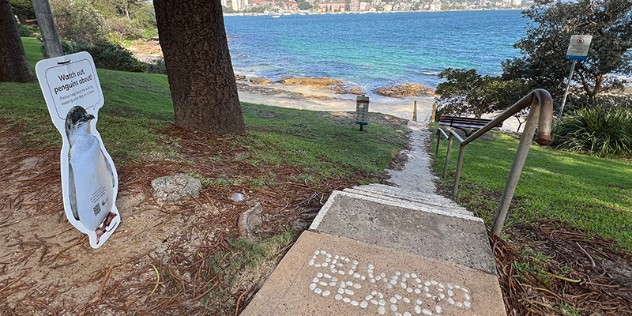
Delwood Beach is one of several beaches leading to Manly Wharf.
The next morning, I traverse the former gas works of Little Manly Point to quiet Collins Beach then climb the hill to North Head Battery. This is a remembrance site, with the Avenue of Honour, Australia’s Memorial Walk and the Third Quarantine Cemetery housing those who succumbed to influenza, smallpox and bubonic plague.
Accessible Fairfax Walk has two stunning new lookouts. Burragula, meaning ‘sunset’, provides a sweeping panorama to South Head and down the harbour. It’s hard to believe I’ve walked it all, and hard to leave it behind as I continue through endangered Eastern Suburbs Banksia Scrub and hanging swamp. With scant shade I’m about to combust when I reach Cabbage Tree Bay Aquatic Reserve. After changing in a sweatbox of a portaloo (a new amenity building is opening soon), Shelly Beach refreshes like a G&T and I lament not allowing time for a swim every day.


The final stretch passes Fairy Bower, a rook pool created by locals in 1929. At Manly’s ocean beach the carnival-like atmosphere of a Nippers State Championship marks the end of my journey. On the NRMA-owned Manly Fast Ferry back to Circular Quay, I buy a celebratory pinot gris. The catamaran zips across the water, concertinaing my five-day harbour circumnavigation to 20 minutes – hardly enough time to finish my wine.
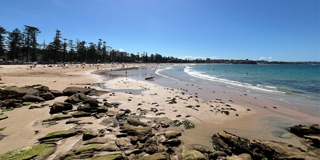
Manly Beach marks the end of the Bondi to Manly Walk.


