PersonalBusiness
About the NRMASupport
MyNRMA Logo
  • About the NRMA
  • Support
Open Road
Road trips
Cairns to Cape York

Cairns to Cape York

Explore wild and remote landscapes on this blockbuster of a road trip from Cairns to the tip of the Cape York peninsula.
egg shaped boulder and mangrove tree on the shoreline of the beach
Lockhart River (Photo credit: Tourism and Events QLD)
20 April, 2018
Written by  
Open Road

What to expect

Duration 7 days. Distance 1964 kms
Leaf icon
Nature
Walking icon
Culture
Turn right
Adventure

Although the Peninsula Developmental Road (PDR) is being progressively sealed, you’ll still need a four wheel drive if you want to explore the national parks with their bird filled wetlands and rainforest, waterfalls and beaches – or tackle the infamously tough Old Telegraph Track with its steep and slippery water crossings. Whatever road you take, driving to The Tip is an adventure like no other.


Day 1: Cairns to Cooktown

6 HRS | 244 KMS

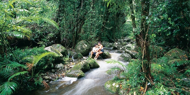
Stop 1: See the sights of the Daintree

Kick off your road trip winding your way along one of the country’s most scenic seaside drives – the Great Barrier Reef Drive from Cairns to Port Douglas. Stretch your legs on a Dreamtime Walk with an Aboriginal guide in Mossman Gorge, take a crocodile watching cruise along the Daintree River or stroll the boardwalks through Daintree Rainforest, which flanks the beach at Cape Tribulation.

Mossman Gorge (Photo credit: Tourism and Events Queensland)


Stop 2: Have a history lesson in Cooktown

Pull over to admire Wujal Wujal (Bloomfield Falls), stop for a cold drink at Lions Den Hotel and visit the James Cook Museum in Cooktown to learn all about Cook’s visit here back in 1770. Then spend a night in style at the Sovereign Resort Hotel.

James Venture Mulligan Statue (Photo credit: Tourism and Events Queensland)


Day 2: Cooktown to Laura

2 HRS| 175 KMS

Stop 1: See rock art galleries in Laura

Laura is home to some of the most impressive rock art galleries in Queensland. Known as Quinkans, the strange long limbed spirits depicted on the many rocky overhangs around town are said to come out and frighten people at night. The displays at the Quinkan and Regional Cultural Centre tell the story, and you can see them for yourself at Split Rock just a few kilometres east of town. Spend some time exploring Rinyirru (Lakefield) National Park. Vast and untamed with fish filled rivers, lily covered billabongs and thousands of birds, it’s Queensland’s Kakadu. Keen to settle down for the night? There are basic rooms at the Quinkan Hotel in Laura, or set up camp beside Old Laura Homestead in Rinyirru (Lakefield) National Park.


Day 3: Laura to Coen

5 HRS | 220 KMS

Stop 1: Dine at a roadhouse

There are good lunch stops on the drive north to Coen, an old Overland Telegraph Repeater Station roughly halfway to The Tip. Drop into Hann River or Musgrave roadhouses, where you can chat with fellow travellers about the latest road conditions.


Stop 2: Step back in time in Coen

Coen Heritage House has some interesting historical displays, although the most photographed (and visited) building in town is the Exchange Hotel – local legend has it that the “S” affixed to the rooftop sign was put up as a dare back in the 1970s, and every time the publican removed it, it would mysteriously appear again overnight. The hotel has motel style rooms and cabins, or you could set up camp on a pretty bend of the Coen River on the outskirts of town.


Day 4: Coen to Lockhart River

6 HRS | 210 KMS

Stop 1: Visit Portland Roads

Take a detour out to the eastern side of the peninsula though the largest remaining area of lowland rainforest in Australia. The beaches here are beautiful – all fine white sand flanked by leaning coconut palms – and the Out of the Blue Cafe in the tiny seaside community of Portland Roads makes a good spot for lunch.

Peninsula (Photo credit: Tourism and Events Queensland)


Stop 2: Buy Indigenous art in Lockhart River

If you’re in the market for unique souvenirs, browse the gallery at the Lockhart River Art Centre. Camp beside the sea on beautiful Chilli Beach or go for something more comfy at the Iron Range Cabins beside the historic aerodrome at Lockhart River.

egg shaped boulder and mangrove tree on the shoreline of the beach

Lockhart River (Photo credit: Tourism and Events Queensland)


Day 5: Lockhart River to Bramwell Station

6 HRS | 154 KMS

Stop 1: See the old Moreton Telegraph Station

Retrace your tracks back to the PDR, and head north on the Telegraph Road, stopping at the Old Moreton Telegraph Station beside the Wenlock River. Built in 1887, the original fort like structure featured turrets with gun ports to help defend the telegraph line in the event of attack from local Aborigines. Today it’s a great spot to stretch the legs and try your luck fishing for barramundi.


Stop 2: Stay at Bramwell Station

Bramwell Station has a campground as well as cabins. You can also camp at Bramwell Junction Roadhouse on the main road to The Tip.


Day 6: Bramwell Station to Bamaga

6 HRS| 212 KMS

Stop 1: Make a splash at Fruit Bat Falls

If you fancy some adrenalin fuelled four-wheel drive thrills, take the Old Telegraph Track (OTT), although you’ll need a winch, snorkel and recovery gear and should be prepared to get stuck at least a couple of times – some creek crossings, like the legendary Gunshot with its near vertical drop, almost always take a couple of goes to get through. An easier option is the Bypass Road, which is still dusty and corrugated and a lot of fun. Don’t miss the chance to cool off in one of the few crocodile free swimming spots on the cape at Fruit Bat Falls.


Stop 2: Enjoy a rest at Balmaga

Once you take the ferry across the Jardine River you are technically in “The Tip”. Bamaga is the main town at the top, although The Tip is actually five communities, all just a couple of kilometres apart. Take a rest at Cape York Peninsula located in the heart of Bamaga. It offers a choice of rooms including suites, deluxe rooms and studios.


Day 7: The Tip

1 HR | 35 KMS

Stop 1: Stand at the northernmost point of the continent

It will take around an hour to drive the sandy track to The Tip, and then it’s a 20-minute walk from the beach to reach the spot with the iconic sign that says, “You are now standing at the northernmost point of the Australian Continent”. But it’s a selfie you have to take. The Tip is rich in history, with wrecked WWII planes rusting away in Lockerbie Scrub, old radar installations at Mutee Head and even older cannons and historic graves at the ruins of Somerset, the earliest – and for a long time, only – European settlement on the cape. Drop a fishing line off the wharf at Seisia and raise a glass to an epic adventure while you watch the sun slip into the sea from the beachside bar on Loyalty Beach, where there’s also a camping ground.

sunset at the tip with sign indicating the northernmost point of the Australian continent

Northernmost point of the continent (Photo credit: Tourism and Events Queensland)

View the route

Loading...
Share this article
facebook
twitter-x
linkedin
Pinterest
Whatsapp
Email

We're for rewarding all Australians

Menu
Membership
Roadside assistance
Cars and driving
Car batteries
Car insurance
Driving lessons
Travel
Quick links
Renew membership
Request roadside assistance
Join My NRMA Rewards
My NRMA app
Find offers and discounts
Find electric vehicle chargers
Support
About us
Who we are
Our community impact
Careers
Media
Connect with our community
instagram
facebook
youtube
twitter-x
linkedin
©️2025 National Roads and Motorists’ Association Limited. ABN 77 000 010 506.
Sitemap
Privacy policy
General conditions
Cookie policy